


North America: Where's the Snow?
ANALYSIS - There has been virtually no snow up in Canada, no snow in the northern US Plains, and the Upper Midwest has seen only two snow events this winter and neither was hugely significant, so we wonder "Where's the snow?", writes Sarah Mikesell, ThePoultrySite senior editor. 1 February 2012
 8 minute read
 By:
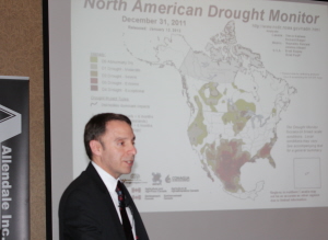
By: Drew Lerner, president and senior agricultural meteorologist of World Weather, answered that question as he presented his weather explanations, expectations and forecast for 2012 to US grain farmers and livestock producers at the Allendale Ag Leaders Outlook Conference held January 20-21 in Crystal Lake, Illinois, USA.
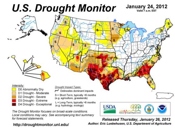
At this time last year, growers in parts of the US feared flooding going into the spring because there had been so much snow, but this year it's the drought monitors for North America that are concerning, Lerner said. The way it looks now around the world, the most interesting weather for this growing season may be in the United States.
"It's the dryness in Texas that got so much publicity last year, but it was far more extensive than Texas," he said. "The dryness reached up into the central Plains, and down into Mexico. The degree of severity in Mexico right now is probably worse than it is in Texas. Texas did get a little bit of precipitation before the autumn season turned into winter."
La Niña's Influence
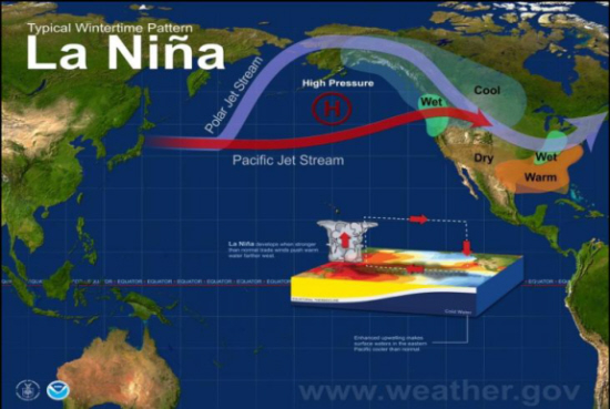
Lerner said it's important to pay close attention to the La Niña event that is playing out right now because it could have a huge impact on the summer season. La Niña started about a year ago and died out in April or May, and then regenerated itself later in the summer.
"We have dryness in Canada. We have dryness in the northern US Plains and dryness in the Upper Midwest, dryness in the southern Plains, dryness in Mexico, and dryness in the Southwest," he said. "It's the middle of winter, when normally we start seeing improvements in the moisture situation, but we're still drying out in the western part of North America right now. Canadian farmers are also worrying about the lack of snow, and there's lots of concern that they are in for a drought this year."
The storms the US have seen so far this season, outside of the lower eastern Midwest, have really had trouble generating moisture which is a symptom of La Niña, especially a La Niña that's in its second year of existence. La Niña takes moisture out of the atmosphere, which is why it's important to pay attention and monitor it over the next few months.
Warmer-than-Normal Temps
Temperature anomalies have occurred for the past six months in North America - not only in Canada, but in the northern US Plains and over a big portion of the US.
"Whenever Mother Nature persistently creates the same anomaly for multiple months - when you get down to a six-month level, she always goes the other way," he said. "So, at some point down the road, it's going to start turning cooler than normal."
The anomalies, going back to last August and September, are pretty phenomenal. Lerner said winter wheat came up in Canada that actually lost hardiness and started to try to green a bit. The same thing was happening in Europe due to warm weather and a lack of snow. He said the only place that's been cold so far this season on a persistent basis has been eastern Siberia and parts of northeastern China.
Soil Moisture
"A year ago, we were already so deep with snow that it was obvious that if it didn't start melting quickly, we were going to have a bad flood in the spring, which, of course, we did have," he said. "This year we don't have to worry about that. Because not only do we not have a snow to melt, we don't have much moisture in the ground either."
The drought monitor suggests there are a lot of areas in the US and Canada that are really low on soil moisture. Flooding should not be an issue this year, not for the upper parts of the Midwest or the northern Plains. However, there is quite a bit of moisture in the lower eastern Midwest and Southeast.
La Niña will tend to increase soil moisture in the Delta, the Tennessee River basin and the lower Ohio River basin. And higher moisture usually continues right through March and April.
Arctic Oscillation
"The typical response in the atmosphere for La Niña in the autumn is to dry out and warm up a bit, so having a warmer bias is not all that unusual. But usually later in autumn or early winter, La Niña will create a cold surge or period of colder than normal temperatures that will dominate a big part of the Canadian prairies and the US northern Plains, and the Pacific Northwest. But that has not occurred," Lerner said.
Arctic Oscillation is related to how much high pressure there is in the arctic. It's common and occurs year round, but in the autumn and winter it's a dominating force.
This high pressure lives in the Arctic above the North Pole. The stronger the high pressure system is, the more pushing down effect it has on the surface, because high pressure is a stronger amount of air pushing downward.
As more and more cold air heads to the surface, it spreads out and goes down our sphere to the lower latitudes - we call this the negative phase of Arctic Oscillation. As a result, we get colder air moving further south than normal.
"That is certainly not the case the last few months," Lerner said. "We were in the positive phase of Arctic Oscillation, which has the opposite effect. The high pressure system in the arctic was windy and very, very weak. It was not capable of pushing a lot of cold air to the surface. The jet stream was allowed to creep higher in the atmosphere and the latitudes. The storm tracks further north and the temperatures were warmer in many areas."
Artic Oscillation Weakens; La Niña Strengthens
This winter, Arctic Oscillation was strongly positive, while the La Niña event has been weak, nothing like it was a year ago, said Lerner. Because it was somewhat weak in September, October, and November, there was plenty of opportunity here for the Arctic Oscillation to overcome the biases of La Niña.
La Niña, up until two weeks ago, was insignificant relative to Arctic Oscillation. However, the Arctic Oscillator has shifted back to a more usual negative position, and at the same time La Niña has strengthened. So, we have fallen back to a more traditional La Niña influence on North American weather.
"We are shifting gears because Mother Nature tends to go from one extreme to another," he said. "The Arctic Oscillator will not go back to the strong positive phase; it does not work that way."
While La Niña could weaken over the summer, Lerner believes it will leave a footprint around in the atmosphere after it goes away, meaning the atmosphere will stay in that mode for a while.
"Even after the La Niña event passes on, it takes a while for natural processes in the atmosphere to change back to normal - whatever normal is," he said. "My forecast is built towards La Niña hanging on and giving the US and parts of Canada a little drier bias, making this year perhaps more interesting, as far as the number of areas in the US that could have some dryness issues."
Texas
No other year has Texas been drier than it was in this past season. Looking historically at the year following a significant drought, Texas weather usually rebounds by about 50 per cent.
"There was a tendency for hydrologic drought to linger behind," he said. "A hydrologic drought is a drought that is low water - reservoirs, rivers and streams running low. Sometimes in a hydrologic drought, you get enough moisture to support crops."
Lerner said Texas is not going to be fully recovered from the drought, no matter what happens over the next few months. Texas may see moisture come around and improve the crops at the surface level, but the long-term drought is not going to go away in the short-term.
Lerner's 2012 North American Forecast
Spring: Expect cool conditions to balance the warmer-than-normal winter. The precipitation anomaly for early spring is going to continue to be below average on precipitation in the Northern Plains. In early spring, expect to see a wet bias in the Ohio River basin and parts of the Delta, which could delay planting. Canadian prairies are also expected to be cooler than normal.
Early summer: Into May and June, the drier, warmer bias in the Northern Plains will continue to perpetuate itself, allowing crops in this area to be planted fairly quickly. The moisture abundance in the Midwest should diminish as we enter the May/June time period. The dryness in the Southeast could shift up into the Ohio River basin and change the moisture level. A drier bias in Canada is expected with cooler than normal temperatures expected for an extended period of time, likely another five or six months.
Mid-summer: There's the ridge in the middle of the country. The heat ridge carries a trough of low pressure over the eastern US. And that suggests that there will be more rain that will occur in the eastern part of the Midwest than last year. Any dryness that shows up in Indiana, Ohio, and Kentucky in the spring should go away moving into the summer. The southeastern US should see an abundance of precipitation as we move deeper into the summer season. Canada is expected to counterbalance herself a little bit with a little less heat throughout the summer.
Late summer: A drier bias is expected. Harvest should go extremely well. It'll be dry in the northern Plains, so they should be done with harvest early. The rest of the country should expect a normal harvest.

Sarah Mikesell
Sarah Mikesell grew up on a five-generation family farming operation in Ohio, USA, where her family still farms. She feels extraordinarily lucky to get to do what she loves - write about livestock and crop agriculture. You can find her on LinkedIn.